


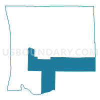
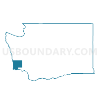
Naselle Voting District, Pacific County, Washington
About
Outline

Summary
| Unique Area Identifier | 687855 |
| Name | Naselle Voting District |
| County | Pacific County |
| State | Washington |
| Area (square miles) | 230.88 |
| Land Area (square miles) | 205.52 |
| Water Area (square miles) | 25.36 |
| % of Land Area | 89.01 |
| % of Water Area | 10.99 |
| Latitude of the Internal Point | 46.40974890 |
| Longtitude of the Internal Point | -123.69064520 |
Maps

Graphs
Select a template below for downloading or customizing gragh for Naselle Voting District, Pacific County, Washington


Neighbors
Neighoring Voting District (by Name) Neighboring Voting District on the Map
- Chinook Voting District, Pacific County, WA
- Deep River Voting District, Wahkiakum County, WA
- Frances-Lebam Voting District, Pacific County, WA
- Grays River Voting District, Wahkiakum County, WA
- Mauermann Voting District, Lewis County, WA
- Menlo-Firdale Voting District, Pacific County, WA
- Nahcotta Voting District, Pacific County, WA
- Nemah Voting District, Pacific County, WA
- Oysterville Voting District, Pacific County, WA
- Pioneer Voting District, Pacific County, WA
- Seaview 2 Voting District, Pacific County, WA
- Skamokawa Voting District, Wahkiakum County, WA
Top 10 Neighboring County Subdivision (by Population) Neighboring County Subdivision on the Map
- Astoria CCD, Clatsop County, OR (24,939)
- Long Beach-North Beach Peninsula CCD, Pacific County, WA (9,107)
- Raymond CCD, Pacific County, WA (7,892)
- Winlock-Pe Ell CCD, Lewis County, WA (7,092)
- Naselle CCD, Pacific County, WA (2,320)
- Willapa Valley CCD, Pacific County, WA (1,601)
- Grays River CCD, Wahkiakum County, WA (962)
- Skamokawa CCD, Wahkiakum County, WA (620)
Top 10 Neighboring Place (by Population) Neighboring Place on the Map
Top 10 Neighboring Unified School District (by Population) Neighboring Unified School District on the Map
- Astoria School District 1, OR (13,648)
- Ocean Beach School District, WA (10,032)
- Wahkiakum School District, WA (3,148)
- Naselle-Grays River Valley School District, WA (2,240)
- Willapa Valley School District, WA (2,231)
- Pe Ell School District, WA (1,737)
Top 10 Neighboring State Legislative District Lower Chamber (by Population) Neighboring State Legislative District Lower Chamber on the Map
- State House District 20, WA (141,029)
- State House District 19, WA (126,904)
- State House District 31, OR (62,690)
Top 10 Neighboring State Legislative District Upper Chamber (by Population) Neighboring State Legislative District Upper Chamber on the Map
- State Senate District 20, WA (141,029)
- State Senate District 19, WA (126,904)
- State Senate District 16, OR (122,983)
Top 10 Neighboring 111th Congressional District (by Population) Neighboring 111th Congressional District on the Map
Top 10 Neighboring Census Tract (by Population) Neighboring Census Tract on the Map
- Census Tract 9715, Lewis County, WA (7,092)
- Census Tract 9501, Wahkiakum County, WA (3,978)
- Census Tract 9504, Pacific County, WA (3,921)
- Census Tract 9503, Pacific County, WA (3,625)
- Census Tract 9504, Clatsop County, OR (3,492)
- Census Tract 9505, Pacific County, WA (2,475)
- Census Tract 9508, Pacific County, WA (2,374)
- Census Tract 9900, Clatsop County, OR (0)
Top 10 Neighboring 5-Digit ZIP Code Tabulation Area (by Population) Neighboring 5-Digit ZIP Code Tabulation Area on the Map
- 98577, WA (6,338)
- 98640, WA (4,380)
- 98631, WA (3,243)
- 98586, WA (1,944)
- 98624, WA (1,532)
- 98638, WA (1,525)
- 98647, WA (404)
- 98614, WA (353)
- 98621, WA (276)